|
It took six years, hundreds of experts and over
2,500 pages of information, analysis and commentary.
On November 24, 2010, the county published the Final
EIR (FEIR) for the Phelps application, which
includes: the Draft EIR and its appendices;
responses to comments on the DEIR, Errata to the
DEIR and Appendix K – Additional Information Used to
Address Comments on the DEIR.
There were 60 individuals and agencies that
commented on the DEIR; 63% of the individuals who
commented supported the project, primarily because
it will drastically cut the number of miles that
Toro Area residents drive on Highway 68 to meet
daily needs like buying groceries, mailing letters
or meeting friends for food or coffee.
County officials will rely on the FEIR for
information about ways to mitigate environmental
impacts and protect local groundwater supplies.
If you would like to review the components of the
FEIR, follow the links below:
Highlights from FEIR
“A positive water balance can be achieved with use
of LEED conserving technology and planting xeriscape
and drought tolerant landscaping.” Page 14
The LEED alternative will “achieve a
net benefit
to the ground water basin.” Page 19
Click here
to download Water Balance chart.
“The VMT [Vehicle Miles Traveled] reduction that
will be achieved by the project” will help the
county meet GreenHouse Gas emission reduction
targets. Page 287
|
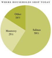 |
In 2002, an
independent survey of 3000 Toro Area
households documented that 59% of local
residents drive 15-20 miles to shop in
Salinas, 25% drive to Monterey and 16%
drive to Seaside or another community to
shop. According to the Final EIR, the
proposed Phelps shopping village will
result in a net reduction of 3,470
vehicle miles traveled every day (mostly
on Highway 68). |
The DEIR finds that local residents who now shop in
Monterey, Seaside or Salinas, would be able to shop
closer to home, resulting in “a net reduction of
3,470 vehicles miles traveled per day” and reducing
the community’s carbon footprint. Page 382
"The project site is the only commercially zoned
parcel along the Highway 68 corridor. It is
centrally located between Salinas and Monterey, and
is level. There are not any other sites that meet
this criteria." page 289
|